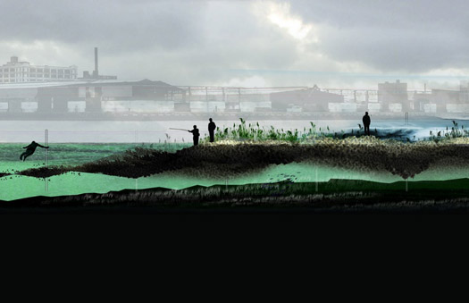
 SCAPE's proposal for a reef that reduces the impact of storm surges and serves as a home for oysters.
This past Saturday afternoon the place to be was the P.S. 1 Contemporary Art Center in Long Island City, Queens. More than 300 people shoehorned themselves into a gallery in the former public school — sitting on folding chairs, standing along the edges of the room and finally claiming floor space up front. They were there to hear a status report on “Rising Currents: Projects for New York’s Waterfront,” a program undertaken by the Museum of Modern Art and P.S. 1 to address the potential effects of climate change on coastal areas in the New York City region. As the temperature in the crowded room climbed, five multidisciplinary teams took turns sketching out their still-evolving proposals for how specific sites along New York Harbor might prepare for rising sea levels and catastrophic storms. The presentation was both sobering and upbeat.
The sobering part came first. Barry Bergdoll, the Philip Johnson chief curator of architecture and design at MoMA, cited climate-change findings from a two-year study that prompted him to organize “Rising Currents.” The study, by leading structural engineer Guy Nordenson, warned that waters around the city could rise 2 feet by 2080; more recent estimates, based on current rates of polar ice cap melt, put the increase at 6 to 8 feet, according to Bergdoll. In his PowerPoint presentation, he clicked through maps from the study showing how the more frequent storms associated with climate change could flood low-lying land bordering the harbor — now you see New York; now you don’t.
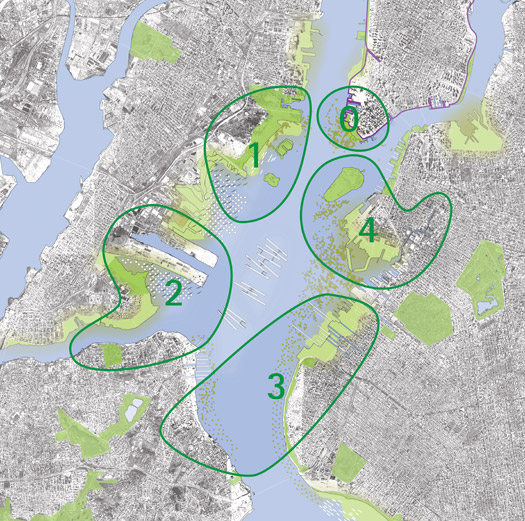
But if the prospect of an incredible shrinking city was dismaying, the “Rising Currents” teams — each assigned a separate study area, but encouraged to think about New York Harbor holistically — at least had plans for a watery future. Since mid-November, these small, handpicked groups of architects, landscape designers, urban planners and artists had been holed up in studios at P.S. 1 (when they weren’t out tromping through their sites or meeting with experts in dredging, shipping and even, in the case of the team planning for the Gowanus Canal area, knitting). In keeping with the broad recommendations of the Nordenson study, they’d dreamed up flexible, ecologically attuned schemes for their sites — “soft” proposals as opposed to “hard” solutions like retaining walls and concrete barriers. And if some aspects of their plans hadn’t fully jelled yet, well, the teams had a couple more weeks to pull together final drawings and models, which will be part of the “Rising Currents” exhibition, opening at MoMA on March 24.

Map of "Rising Currents" project zones. Designers: Guy Nordenson and Associates, Catherine Seavitt Studio and Architecture Research Office with Lizzie Hodges, Marianne Koch, James Smith and Michael Tantala.
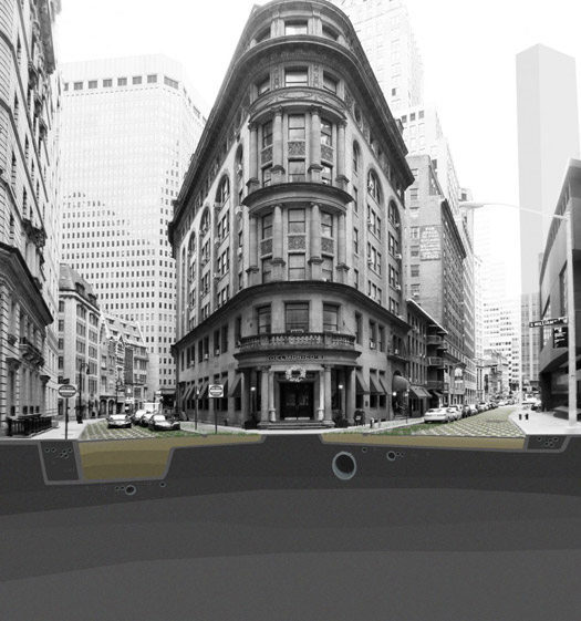
The team that tackled the lower Manhattan study area — Adam Yarinksy (co-author of the Nordenson report, titled On the Water: Palisade Bay) and Stephen Cassell of Architecture Research Office (ARO), with landscape architect Susannah Drake of dlandstudio — propose to green their densely built district with the water from rainfall and tidal surges. Goodbye, asphalt (which simply channels rain into storm-water drains). They would pave streets with a mesh of cast concrete filled with specially engineered soil and salt-tolerant plants that would sponge up moisture. Around the tip of the island, new landfill would be added; on it wetlands and tidal marshes would flourish, acting as a buffer for tides.
In the “amphibious” scenario for the study area just across the Hudson River, encompassing New Jersey’s Liberty State Park, the existing land would be reshaped. This site, constructed in large part by dredging and infill between 1880 and 1920, is dramatically flat and therefore would be easily flooded by rising waters, according to team leaders Paul Lewis, Marc Tsurumaki and David Lewis, partners in LTL Architects. They would sculpt the level expanse into four raised fingers stretching into the Hudson, doubling the coastline. Each finger would have a broadly defined theme: one devoted to recreation, for example, might contain an outdoor concert space, with seating on floating barges.
For the Kill Van Kull study area, architect Matthew Baird and his team took inspiration from beach glass they found as they walked along the shores. They would turn a deteriorating World War II–era storage building on one of the mega piers in Bayonne, New Jersey, into a recycling facility where beverage bottles could be recast as 2-foot “modular reef-building units.” These jumbo crystalline jacks could be strewn at strategic points in the harbor, forming reefs that would serve as breakwaters and habitats for marsh grasses and mussels.
An archipelago of barrier islands was part of the “New Aqueous City” Mimi Hoang and Eric Bunge of nARCHITECTS had conjured up for their study area, the Verrazano Narrows and bordering lands. Pointing out that the projected loss of land due to rising sea would occur at a time when New York’s population is expected to increase, the team also proposed a new type of housing “hung” from steel armatures off the coasts of Staten Island and Brooklyn’s Sunset Park. Turning the typical house plan on its head, their designs would provide grassy areas on top and water-viewing windows on the bottom.
If that scheme pointed to a brave, new future on the water, Kate Orff of SCAPE and her Gowanus Canal–area team looked to the past for their solution: the revival of the oyster industry. Oystering, and later oyster farming, thrived in New York, with the tasty mollusks served at oyster bars and from pushcarts until the waters became dirtied. Orff extolled the oyster’s pollution-busting powers — each little bi-valve is capable of cleaning 30 to 50 gallons of water a day, she said — and its ability to form natural reefs. For the shallow waters of the Bay Ridge flats, this team proposed erecting marine posts draped with nets woven of fuzzy rope that oyster spats would cling to. They envisioned a Department of Oyster Production (DOP), not to mention “I [oyster] New York” T-shirts, and, ultimately, the return of a once-popular urban snack. In the team’s second-floor studio — the “Rising Currents” workspaces, wallpapered with site photos and renderings, were open to the public before and after the gallery presentation — team members sat around knitting small-scale versions of oyster nets, giving the space the cozy feel of a knitting circle.

ARO's method of draining rain water and storm water from urban streets into nearby wetlands.
Whether an oyster revival or any of the other “Rising Currents” proposals come to pass remains to be seen, of course. And with so many governmental entities having jurisdiction in the harbor and adjacent lands, the political challenges, let alone practical ones, are daunting. City officials seem to at least be listening to the new ideas. Many have met with the teams. Amanda Burden, chair of the New York City Planning Commission and director of the Department of City Planning, said through a spokesperson that it was too soon to weigh in on the specific proposals. But Burden, who helped select the “Rising Currents” team leaders, showed up at P.S. 1 on Saturday. She toured the open studios. She sat through the presentation. “I am very excited by what I have seen so far,” she said in an emailed statement. “This unique initiative is an opportunity to rethink the coastlines of New York and New Jersey’s Upper Harbor in an ecologically responsive and imaginative way.”
“Rising Currents,” a full-scale exhibition on climate change and the five workshop proposals, will be on view at MoMA March 24 to August 9, 2010. Additional images and videos can be found at MoMA/P.S. 1's Inside/Out blog. On the Water: Palisade Bay, by Guy Nordenson, Catherine Seavitt, and Adam Yarinsky, will be published in March by the Museum of Modern Art in association with Hatje Cantz Verlag.
